


Geosciences 2024, 14(5), 124; https://doi.org/10.3390/geosciences14050124 - 02 May 2024
Abstract
Imaging spectroscopy allows us to identify surface materials by analyzing the spectra resulting from the light–material interaction. In this preliminary study, we analyze a pair of hyperspectral cubes acquired by PRISMA (on 20 April 2021) and EO1- Hyperion (on 4 July 2015) over
[...] Read more.
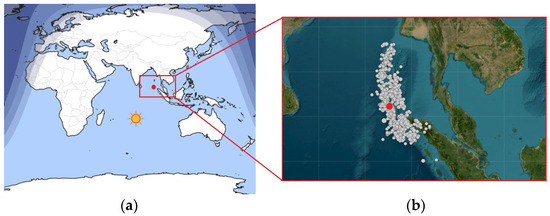
Imaging spectroscopy allows us to identify surface materials by analyzing the spectra resulting from the light–material interaction. In this preliminary study, we analyze a pair of hyperspectral cubes acquired by PRISMA (on 20 April 2021) and EO1- Hyperion (on 4 July 2015) over the Indonesian Lusi mud eruption. We show the potential suitability of using the two sensors for characterizing the mineralogical features in demanding “wet and muddy” environments such as Lusi. We use spectral library reflectance spectra like Illite Chlorite from the USGS spectral library, which are known to be associated with Lusi volcanic products, to identify minerals. In addition, we have measured the reflectance spectra and composition of Lusi sampled mud collected in November 2014. Finally, we compare them with reflectance spectra from EO1-Hyperion and PRISMA. The use of hyperspectral sensors at improved SNR, such as PRISMA, has shown the potential to determine the mineral composition of Lusi PRISMA data, which allowed the distinction of areas with different turbidities as well. Artifacts in the VNIR spectral region of the L2 PRISMA reflectance product were found, suggesting that future work needs to take into account an independent atmospheric correction rather than using the L2D PRISMA product.
Full article
(This article belongs to the Special Issue Remote Sensing Monitoring of Geomorphological Hazards)


